The 2001 Nisqually earthquake shook western Washington state on February 28. The 6.8 magnitude earthquake caused billions of dollars in damage. Remembering the Nisqually earthquake 20 years later is an important reminder to the Pacific Northwest that this region is a part of earthquake country.
Nisqually Earthquake Facts
The Nisqually earthquake struck at 10:54am on February 28, 2001, 11 miles north of Olympia, Washington. Watch live footage taken during the earthquake from National Geographic:
According to the U.S. Geological Survey, the earthquake was felt hundreds of miles away including in southern British Columbia, central Oregon, and northwestern Montana. The shaking lasted less than one minute, but quickly caused over a billion dollars in damages.
The only death associated with the earthquake was a heart attack victim. However approximately 400 people were injured as a result of the quake. This was the biggest earthquake in the region since the 6.7 magnitude earthquake in 1965.
The quake originated on a fault that lies more than 35 miles under the Nisqually Delta, giving the earthquake its name. In comparison, many quakes in California occur at depths less than 6 miles.
Because of its depth, the Nisqually quake caused less-severe shaking intensity than a shallow magnitude 6.8 would have. By comparison, the magnitude 6.7 Northridge earthquake in 1994, which occurred at a depth of 11 miles, caused 57 deaths and $20 billion dollars of losses.
Even Bigger Earthquakes: Cascadia Subduction Zone
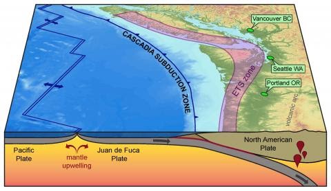
The Pacific Northwest can experience much larger earthquakes than Nisqually. The offshore Cascadia Subduction Zone can create earthquakes up to magnitude 9. This is where the Juan de Fuca tectonic plate is sliding under the North American plate at about 3.5 to 4.5 centimeters per year. The Cascadia Subduction Zone places western Washington under increasing pressure for earthquakes and is also responsible for the chain of volcanoes known as the Cascade Range.
The 2001 Nisqually earthquake served as an important reminder of the need for emergency preparedness planning and infrastructure upgrades.
Damages Caused by the Nisqually Earthquake
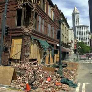 The earthquake caused serious damage to many buildings, roads, and bridges. Olympia, Washington was hit especially hard, including damage to the state capitol building.
Older downtown Seattle experienced heavy damage along with the Boeing Field runway and the air traffic control tower at SeaTac Airport. Brick buildings in Pioneer Square in Seattle were also heavily impacted including the Cadillac hotel pictured here.
Seismic Upgrade of the Alaskan Way Viaduct
As a result of the earthquake, cracks developed in the State Route 99 Alaskan Way Viaduct. After the viaduct suffered some support sagging it was deemed to fail in the event of another earthquake. This damage ultimately led to its replacement with the State Route 99 tunnel under downtown Seattle in February, 2019. With a cost of close to $3.3 billion and over a decade of construction, Seattle’s new tunnel is now designed to hold up against a major earthquake such as the potential magnitude 9 Cascadia Subduction Zone earthquake which could hit off the coast of Washington.
While the new State Route 99 tunnel in downtown Seattle was the most prolific project to result from the quake, it was certainly not the only one. As much of the damage involved older unreinforced masonry or concrete buildings, many buildings and bridges were retrofitted. Additionally seawalls were reconstructed and the emergency operations center in Seattle was moved in 2008 to a building with a higher seismic standard. Many retrofit projects continue in Washington to this day.
Do you want to know more about how cities can keep buildings safe during earthquakes? Visit our blog More Ways to Keep Buildings Safe in Earthquakes for a deep dive into the innovative protective systems and how these technologies help buildings resist earthquakes.
The Next Pacific Northwest Earthquake
While the Nisqually earthquake was significant, it is only considered to be a “moderate” quake for the region, according to Bill Steele, Pacific Northwest Seismic Network communications director. The Cascadia Subduction Zone off the Pacific Coast and the Seattle Fault, both have the potential to generate larger earthquakes.
Western Washington residents have been warned that the region is due for the “Big One.” Researchers have raised concerns about the lack of any other significant quakes in the Pacific Northwest since Nisqually. The Pacific Northwest faces nearly as much earthquake risk as California, so preparation is essential for residents in this area.
Tips for Earthquake Preparation
The 20 year anniversary of the Nisqually earthquake is the perfect opportunity to spend a day making sure you are prepared for the next inevitable quake.
How to prepare for an earthquake:
- Remember and practice the safety technique: drop, cover, and hold on.
- Sign up for phone apps like Quake Alert, powered by USGS’s Shake Alert, soon to be available in Oregon and Washington. You can also purchase a wall-mounted earthquake alarm that can give you a few seconds of warning to drop, cover, and hold on.
- Stock up on essentials for your earthquake preparedness kit. Make sure you have a solar charger, when the power is out, your phone will be your essential lifeline.
- Make an emergency plan including a communication plan.
-
-
- Quick Tip: Write down on a piece of paper and keep it in your wallet: the cell phone numbers of your spouse/children/parents and the phone numbers of the school/workplaces where they are during the day.
-
- Earthquake-proof your home by fastening your furniture and utilities, bolting your foundation, and bracing cripple walls.
- Plan for financial resilience in the immediate aftermath of an earthquake with Jumpstart.
Did you know? Jumpstart recently launched in Oregon and Washington! This parametric insurance product pays a lump-sum right away that policyholders can use to pay for any expense related to the earthquake.
