So far in this series, we’ve covered proximity to fault lines in part one and soil liquefaction and landslides in part two. Another area to look into before buying a house in earthquake country is proximity to dams. Their watersheds cover vast areas, causing massive flooding downstream if the dam fails during an earthquake.
Part 3: An Area of Potential Flooding
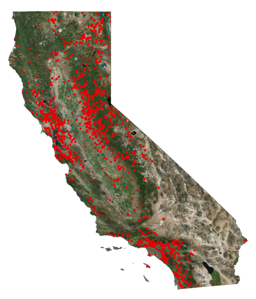
Even if the closest dam to your house is 100 miles away or more, it may still pose a danger after an earthquake. See the map below of the dams in California’s jurisdiction (federal dams not shown).

In February 2017, the Oroville Dam was near-breach. Additional stresses from strong rains and melting snow caused a failure. Thankfully, the dam did not completely fail. If it had, a 30-foot wave would have impacted nearby areas. RMSconnection provides a worst-case scenario animation.
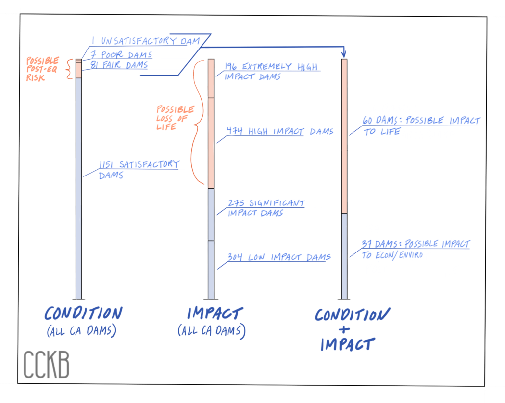
The Oroville Dam crisis drew attention to California’s dams. The Division of Safety of Dams (DSOD) released a dam assessment report for California (not including federal dams) in September 2017. The graph below summarizes the report. The left-most bar shows all dams in California, grouped by their condition. A condition of “fair” means that the dam may fail during an earthquake. A condition of “poor” or “unsatisfactory” means that safety is a concern for that dam, and retrofitting is required. The middle bar shows the dams grouped by their potential impact of failure. An impact “high” or “extremely high” means that loss of life is possible.
The right-most bar shows the subset of dams that could cause post-earthquake impact. There are 60 dams in California that could result in loss of life if that dam fails in an earthquake.

Dams that Could Impact Human Life
Here is a list of all California dams that could result in “dam safety deficiency” after an earthquake (as of September 2017).
| County | Name of Dam | Owner of Dam |
|---|---|---|
| Alameda | Calaveras | City and County of San Francisco |
| Amador | Henderson | Amador Regional Sanitation Authority |
| Butte | Oroville | California Department of Water Resources |
| Contra Costa | Lafayette | East Bay Municipal Utility District |
| Contra Costa | Orinda, Lake | Orinda Country Club |
| El Dorado | El Dorado Forebay | El Dorado Irrigation District |
| Imperial | El Centro Water Purification Plant | City of El Centro |
| Inyo | Haiwee | City of Los Angeles Department of Water And Power |
| Inyo | Tinemaha | City of Los Angeles Department of Water And Power |
| Los Angeles | Bouquet Canyon | City of Los Angeles Department of Water And Power |
| Los Angeles | Castaic | California Department of Water Resources |
| Los Angeles | Sawpit Debris Basin | Los Angeles County Department Of Public Works |
| Madera | Crane Valley Storage | Pacific Gas and Electric Company |
| Mendocino | Feliz North Lake | Brutocao Vineyards |
| Modoc | Kelley Hot Spring Fish | Private Entity |
| Mono | Agnew Lake | Southern California Edison |
| Mono | Gem Lake | Southern California Edison |
| Mono | Lower Twin Lake | Centennial Livestock |
| Mono | Rush Creek Meadows | Southern California Edison |
| Mono | Upper Twin Lake | Centennial Livestock |
| Napa | Araujo Reservoir No. 1 | Kerwin Estate, LLC |
| Napa | Araujo Reservoir No. 2 | Kerwin Estate, LLC |
| Napa | Conn Creek | City of Napa |
| Napa | Lake Curry | City of Vallejo |
| Napa | St. Helena Lower | City of Saint Helena |
| Napa | Veterans Home | California Department of Veteran Affairs |
| Nevada | Lake Angela | Donner Summit Public Utility District |
| Nevada | Lake Fordyce | Pacific Gas and Electric Company |
| Nevada | Lake Van Norden | Truckee Donner Land Trust |
| Placer | Lakewood | The Armtrout Family Trust |
| Riverside | Perris | California Department of Water Resources |
| Riverside | Vail | Rancho California Water District |
| Sacramento | Blodgett | Private Entity |
| Sacramento | Mather | County of Sacramento |
| Sacramento | Willow Hill Reservoir | City of Folsom |
| San Bernardino | Glen Martin | Highest and Best Use, LLC |
| San Bernardino | Gregory, Lake | San Bernardino County Regional Parks |
| San Diego | Barrett | City of San Diego |
| San Diego | El Capitan | City of San Diego |
| San Diego | Hodges, Lake | City of San Diego |
| San Diego | Morena | City of San Diego |
| San Diego | Mt Woodson | Ramona Municipal Water District |
| San Diego | Murray | City of San Diego |
| San Diego | Savage | City of San Diego |
| San Diego | Sweetwater Main | Sweetwater Authority |
| San Diego | Wohlford, Lake | City of Escondido |
| San Mateo | Bear Gulch | California Water Service Company |
| Santa Clara | Almaden | Santa Clara Valley Water District |
| Santa Clara | Calero | Santa Clara Valley Water District |
| Santa Clara | Guadalupe | Santa Clara Valley Water District |
| Santa Clara | Leroy Anderson | Santa Clara Valley Water District |
| Santa Clara | North Fork | Pacheco Pass Water District |
| Santa Cruz | Newell | City of Santa Cruz |
| Shasta | Misselbeck | Igo-Ono Community Services District |
| Solano | Lynch Canyon | Solano Land Trust |
| Sonoma | La Crema Winery | Jackson Family Wines |
| Stanislaus | ConAgra Aerated and Settling Ponds | ConAgra Grocery Products Company, LLC |
| Ventura | Matilija | Ventura County Watershed Protection District |
| Ventura | Santa Felicia | United Water Conservation District |
| Yuba | Camp Far West | South Sutter Water District |
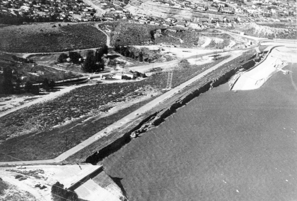
A close call occurred in 1971 after the San Fernando earthquake. As a result of the quake, the Van Norman Dam, an earth dam north of the San Fernando Valley, liquefied the top 30 feet of the dam crest. With fears of a potential failure, officials evacuated 80,000 people in the largest Los Angeles evacuation order. Thankfully, the water level of the dam was lower than usual. Therefor the water did not overtop the dam and there were no casualties. This led to increased understanding of dams made of soils.

Prepare, Prepare, Prepare
Senate Bill 92, passed in 2017, requires the Department of Water Resources to make publicly-available inundation maps for each of its dams and provide updates every ten years. Refer to the California Department of Water Resources website for the approved inundation maps. The owners of the dams must have the maps available by January 1, 2019. For any maps not yet released, contact PRA@caloes.ca.gov to request dam inundation data.
Above all, if you are in a post-earthquake potential flooding area, it’s even more critical to have an emergency kit that includes a radio to receive evacuation alerts. Also be sure to have a communication plan with your family and a planned evacuation area.
Be mindful of your location and always be prepared.
- California Geological Survey map
- California Geological Survey Information Warehouse
- FEMA Report: Know Your Risks
–
This article is educational and informational in nature, and not intended as legal, expert or other professional advice, or as any form of recommended minimum standard or best practice. Be advised to carefully review the information presented with qualified professional advisors prior to acting upon or implementing said ideas.

